Projects
Examples of CSP2 Projects
Proposed Pebble Mine, Bristol Bay, Alaska:
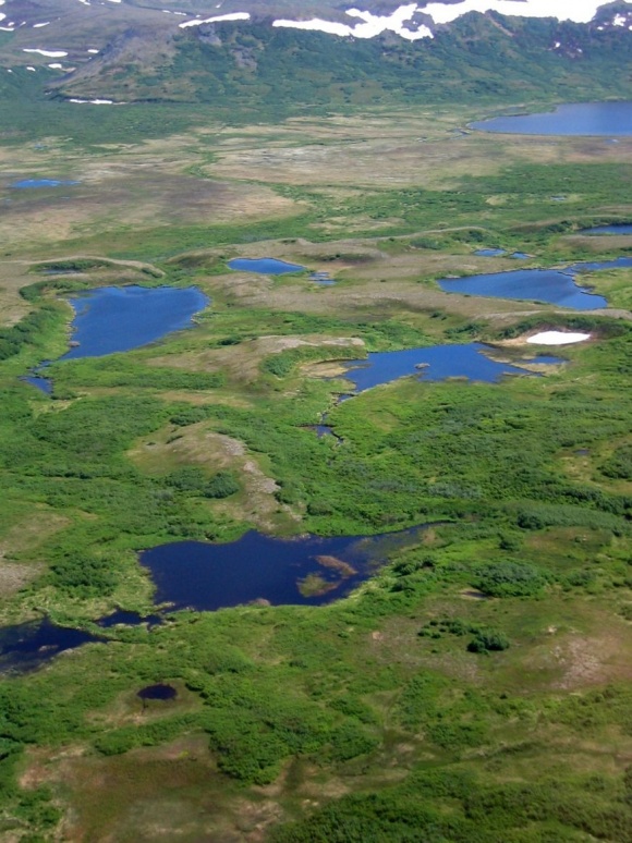
The proposed Pebble open pit would be in the upper center of this photo, in the relatively flat area below the hills.
The Pebble deposit is a large, low grade, copper-molybdenum-gold ore body located north of Lake Iliamna, the largest lake in Alaska. The mine is located in the Bristol Bay region of southwest Alaska, about 200 air miles from Anchorage. The region is largely inhabited by Native Alaskans, and there is no road access to the region. If developed, the mine would likely be the largest in North America.
Since 2007 CSP2 has been providing technical support to a loose coalition of groups opposed to the proposed mine. Dave Chambers, (general mining), Kendra Zamzow, (geochemistry), and Stu Levit, (reclamation and regulatory), have provided support from CSP2. CSP2 also utilized consultants Carol Ann Woody, Ph.D., and Sarah O’Neal, M.S., from Fisheries Research and Consulting to provide support on fisheries biology, and Ann Maest, Ph.D., and Cam Wobus, Ph.D., from Stratus Consulting to provide technical support on geochemistry and hydrology. Bretwood Higman, Ph.D., from Ground Truth Trekking provided fault and seismic research.
The research efforts of this technical team have led to a significant number of publications and professional presentations. Dave Chambers, and CSP2 consultant Bretwood Higman, developed a paper on the “Long Term Risks of Tailings Dam Failure” which has been presented at several professional meetings. Kendra Zamzow collected and analyzed water quality data from several sites in the area of the proposed mine “Investigations of Surface Water Quality in the Nushagak, Kvichak, and Chulitna Watersheds, Southwest Alaska, 2009-2010.” Stratus Consulting has developed a state-of-the-art computer hydrologic model that is being used to develop predictions of groundwater and surface water flows, and the geochemistry of those waters, which would result from the development of the mine. Fisheries Research and Consulting has been involved in a multi-year survey to collect data on the presence of salmonids in the area, “Fish Surveys in Headwater Streams of the Nushagak and Kvichak River Drainages, Bristol Bay, Alaska, 2008 – 2010.”
EPA released its Draft “Bristol Bay Watershed Assessment” in May, 2012. This is a significant scientific effort to evaluate the potential impacts of the Pebble mine on the Bristol Bay ecosystem. Dave Chambers and Kendra Zamzow provided technical critiques of the Draft to EPA with recommendations for improvement. CSP2 is also working with the Bristol Bay Native Corporation in its effort to convince EPA to invoke its power under section 404(c) of the Clean Water Act to veto the Pebble Project because it would have an “unacceptable adverse effect” on fisheries resources in the Bristol Bay region. This is the first time a for-profit Alaska native corporation has taken a position against a mine in Alaska.
For detailed technical infomation on the proposed Pebble mine - hydrology, geology, fisheries resources, etc. - go to the website:
PebbleScience.org
Flambeau Mine, Ladysmith, Wisconsin:
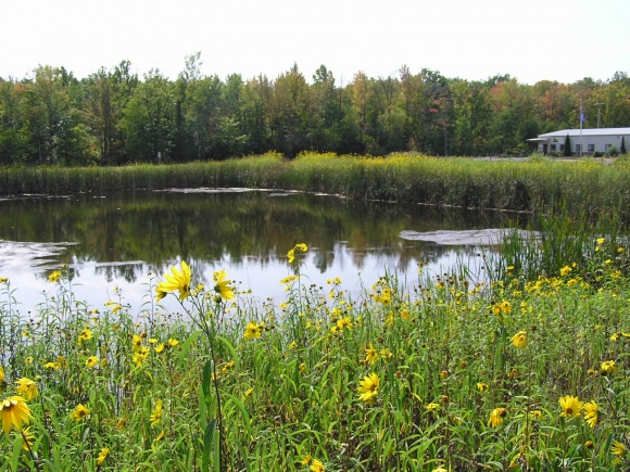
Reclaimed Flambeau Mine Biofilter, which discharges copper at toxic levels
The Flambeau Mine, an open-pit copper-gold-silver mine located near Ladysmith, Wisconsin was permitted in January 1991 and began production in 1993. When mine operations ceased in 1997, the open pit was 220 feet deep, a half mile long and 32 acres in size. When backfill operations commenced over 30,000 tons of limestone was blended into the sulfide-bearing waste rock on relocation. Backfill operations were completed by early 1998, at which time surface reclamation began. This entailed recontouring the surface, spreading topsoil and establishing plant communities.
At the request of the Wisconsin Resources Protection Council CSP2 developed a “Report on Groundwater and Surface Water Contamination at the Flambeau Mine, David Chambers, Kendra Zamzow, June 5, 2009” that documents copper contamination in excess of Wisconsin surface water quality standards reaching the Flambeau River from the Flambeau mine site from the “Biofilter” designed to provide water treatment, and that the Flambeau pit is leaching contaminants that exceed Wisconsin groundwater quality standards to beyond the slurry wall designed to separate pit water from the Flambeau River. The present surface and groundwater monitoring scheme is not sufficient to determine whether either the surface water or groundwater contamination is entering the Flambeau River.
The CSP2 report was used by the Wisconsin Resources Protection Council as technical support for a successful Clean Water Act lawsuit in US District Court confirming that surface water quality violations were ongoing from the reclaimed Flambeau Mine. The Flambeau Mine has been touted by the mining industry and the State of Wisconsin as an example of successful reclamation of a sulfide mine.
In April, 2012, the Wisconsin Department of Natural Resources completed an investigation of water quality at the Flambeau Mine site which resulted in a proposal to include Stream C at the Flambeau Mine site on its list of “impaired waters” for “acute aquatic toxicity” caused by copper and zinc.
Chuitna Coal, Cook Inlet, Alaska:
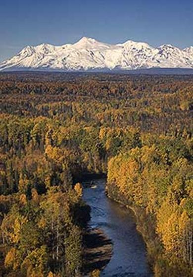
Chuit River and southern end of the Alaska Range
The idea of a coal strip mine in the Chuit River watershed area proposed to be mined includes 20,571 acres from which 300 million tons of coal would be extracted over 25 years in the first phase of mining. Developing the infrastructure would facilitate coal mining on an additional 17,686 acres, for a total of 60 square miles that could be mined.
CSP2 has been providing technical support for Alaskans for Energy Freedom Campaign, and has reviewed reclamation plans, soils reports, geology reports, and water chemistry data, and spoke with remediation consultants, fisheries consultants, and agencies. One of the conclusions of this work is that the area cannot be reclaimed to its pre-mining use.
In order to reach some of the coal seams mining would need to completely remove 11 miles of one salmon-bearing stream, ripping out the underlying material to 350 feet below the streambed. The substratum is primarily saturated sandstone interspersed with sand, gravel, aquifers, and up to 18 layers of coal; the water table lies at the surface in the majority of the region.
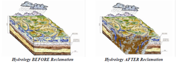
In this seismically active area, weathered volcanic ash near the surface forms a clay-like material that holds water yet contains pores that allow for drainage and facilitate rooting, and a number of different vegetation types can be found. The topsoil is acidic and mining consultants concluded that they should neither be stockpiled for later use nor used as backfill unless they could be isolated from water – an impossibility in this saturated environment. Water chemistry would also change post-mining, with likely impacts on salmon that depend on chemical sensing to return to streams.
- See the PAST PROJECTS page on this website for a complete list of the mining projects on which CSP2 has worked.